| |
Trip to Kabbal Durga and Bandalli
Durga
By Hemant Murthy
Going at just about 55 km/hr,
Sujit was getting quite irritated with me. The road, NH 209 (Kanakapura
Road) is an excellent road, and one can easily touch speeds of 70
to 80 km/hr, but I was riding my poor little Boxer CT, and its 100
cc engine was doing its best to pull my weight on the road. After
my roomies and ex-roomies could not make up their mind on what to
do over the long Christmas weekend, I decided to join Sujit and
Aniket on a bike trip to places south of Bangalore. Aniket backed
out last minute, due to office work load, and so in the end, it
was down to just Sujit and me.
On Wednesday night, we studied some of the survey
maps of south Bangalore, looking for places along the Cauvery river.
We found two places that looked interesting - Kabbal durga, a fort
near Kanakapura, and Bandalli durga, another fort near Kollegala.
Come Christmas morning, and we were welcomed by early morning rains.
By 8:00 AM, the rains had stopped and the clouds had cleared. We
started off immediately for Kanakapura, along NH 209, and stopped
there for breakfast. From Kanakapura, we headed towards Halagur,
and after traveling about 8 kms, we took a right turn towards the
village of Kabbal, which is about 10 kms from NH 209.
Kabbal Durga
Kabbal village is home to the temple of local goddess
Kabalamma, and also to the fort of Kabbal. The fort is built over
a 250m high monolithic rock, with rather steep surfaces on 3 sides
and less steep surface on the fourth side. We climbed along that
side of the rock, avoiding the steps that are cut into the rock.
The climb is along an average slope of about 40 degrees, and gets
quite steep in certain places, where one needs to be careful as
there is nothing to break ones fall. After about 40 mins, we reached
the top of the rock. The top is quite flat, and has a few stone
structures including a temple and something that, according to Sujit,
looked like horse stables (I wonder how they got horses up here!).
It was already noon and was quite hot, but it was very cool inside
the temple. We sat there for some time, talking. We even messaged
Aniket and Rohan about where we were, since the temple was the only
place my mobile picked up a signal (Looks like this god had a cell
phone too). The views from the top were very good. We could see
a number of rocky hills rising up from the ground all over us. Other
than a few trees and thorny shrubs and cacti, there is not much
vegetation on this hill. After some biscuits and water and some
rest, we headed down (we followed the steps while climbing down)
and reached the village by about 3:00 pm.
| To reach Kabbal Durga from Bangalore,
take NH 209 (Kanakapura Road) upto Kanakapura (about 50 kms),
and from there, go towards Halagur for about 8 kms, before turning
right towards Kabbal. From there, the village is about 10 kms.
The fort is visible from the village, and the top is about 1.5
to 2 kms from the village. |
Shivanasamudra
From Kabbal, we got back to NH 209 and biked to Shivanasamudra
(bluff). We reached the place by about 4:30 pm. It's a beautiful
place where the Cauvery River splits into two parts, and each part
splits up further into two waterfalls. The first pair of waterfalls
which are visible from Shivanasamudra is named "Gagan Chukki" while
the other pair, which can be accessed from a place about 12 kms
away, is named "Bara Chukki". Unfortunately, there wasn't much water,
since there wasn't much water being released from the Krishnarajasagar
Dam. We sat there for sometime, feasting on large cucumbers and
tomato slices and left the place at about 5:30 pm.
| To reach Shivanasamudra from Bangalore,
go to Kanakapura, and from there, go towards Malvalli (about
50 kms from K'Pura). At Malvalli, take the road going left,
towards Kollegal. At about 15 kms from Malvalli is a road going
left towards Shivanasamudra Gagan Chukki. From there, the falls
is 5 kms. To reach Bara chukki, do not take this left turn,
but go ahead and cross the bridge after forbes sagar. After
the bridge is a left turn towards Bara Chukki (which is 5 kms
from this point). |
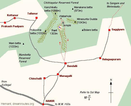
Bandalli
Durga
From Shivanasamudra,
we started towards Kollegal, after crossing the bridge over Cauvery.
On the way, we saw a beautiful sunset, much better than what we
saw on the beach trek. The sun was a perfectly round disc of glowing
red against a very dark background, and it slowly set behind some
hills on the horizon. We realized we had some distance to cover,
and it was already getting dark. After a brief halt at Kollegal
for directions (from a very knowledgeable person, who also knew
about the fort), we proceeded towards Hanur. We reached Hanur at
about 8:00 pm, where I asked for directions to Bandalli Village
at the forest checkpost. This was a big mistake, since we were questioned
as to why we were going to the fort, etc. Our repeated explanations
that we were only trekkers were to no avail and we were warned to
keep of the fort (and even the village), since it was inside reserved
forest, and we were given all possible reasons of death, ranging
from Veerappan and STF to Wild Animals like Elephants (in the middle
of being surrounded by almost the entire Hanur Village public, who
wanted to know what was going on). Though I was upset (more because
of the cold behavior of the forest office staff and police), Sujit
emphasized that we move on and atleast go to the village (which
was NOT in the reserved forest area, unlike the fort), where we
could catch some much needed sleep. So after dinner at Hanur, we
took our bikes to Bandalli, and reached the village at about 9:00
pm.
Here we were greeted in a contrast way. The villagers
(who were rather surprised to see two persons with bags coming to
their small settlement in the middle of the night) welcomed us and
told us that there was no problems in climbing to the fort, if we
did so in the day time (I don't know why they thought we wanted
to climb through 9 kms of Elephant Forest in the middle of night!).
One person, named Rajesh, offered his farm house, where his younger
brother stayed and tended to the farms, for us to spend the night
in. He spent some time with us telling us stories about the fort
and its history, and about how a few people from Bangalore and other
nearby cities do come to their place to climb to the fort every
year. He promised to arrange for a guide next morning to take us
to the fort. We spent a rather sleepless night (because of the mosquitoes),
and woke up early morning, to be welcomed by, guess what, rains!
(d�j� vu?). Luckily for us, the rains subsided quickly, and by 9:00
am we were off to the fort after a quick breakfast at the village
hotel.
As promised, Rajesh had arranged a guide, named Nachappa,
for us. Nachappa is a slighty old, balding man with an amazing stamina
that'll put all us young city slickers to shame. With a sickle in
his hand (to cut thorny plants), he led us northwards (due north
again!), through the farms, and then through an open jungle and
towards the hill. The top of the hill was not visible because of
the clouds that had gathered around it. But as time went by, the
clouds cleared to reveal the fantastic shape of the hill. On top
of the hill, which is about 600m above the ground below, was a 100
m or more high rock, which was about an acre or more on the top.
On top of that rock was built a fort. As we climbed northwards and
up the ridge along the western side, we could make out more details
like the fort wall and some structures on top. We walked a little
beyond the rock, towards the north, and then turned around and climbed
the rock from the north-western side, which is the easiest way to
access the fort. Thanks to Nachappa, who maintained a very steady
pace, we managed to ascent the fort in about 2 hrs, stopping briefly
on the way to appreciate some beautiful views of the areas around
us. Before climbing the last few steps, Nachappa showed us the perennial
well (shown as a blue dot on the map) near the top of the fort,
named Kalyani Kala. From this place, there are a set of steps leading
to the top of the rock, where the kings house used to be.
 |
The fort
used to be protected by a unique defense system. The final few
meters to reach the top are over a slanting boulder. This bolder
almost overhangs kalyani kala, at a height of about 200 feet
over it, and slopes down towards it at an angle of about 45
degrees. According to our guide, in times of attack, this boulder
would be covered with oil. Any attempt to reach the kings house
over this boulder would result in a person slipping and falling
into Kalyani. |
The fort is protected by three levels of walls on the
climbable side, and by the natural structure of the huge rock it's
built on. On top are a few stone structures, though their purpose
are not really clear (may have been quarters for troops or workers,
or even the king himself). The fort is built at a height of 1300
m above SL, and is one of the highest hills in the area. From the
top, one can see all around up to great distances. No wonder the
king built a fort here, from where he could keep watch over a large
number of villages. The views are absolutely stunning, and one of
the best I've seen so close to Bangalore. On the west is high ridge,
going north to south, while there are a number of hills and ridges
all around. From the top, one can see the hills of Mahadeshwara
Malai Hills (M. M. hills) and also Biligi Ranganna Betta (B. R.
hills) and all the forests in between. After spending a good hour
on top, enjoying the views and studying the maps, we started downwards
towards a temple and pond to the north of the fort, which we could
see from the top.
The descent was quite thrilling, with a part of it literally
along the almost vertical face of the rock (People from Due North,
remember our cliff climb, sleep and descent?). Nachappa cut a path
for us amidst the thorny plants and tall grass (which cut our hands
and fingers), and led us towards the temple, which is a little more
than a kilometer to the north of the fort. The temple is dedicated
to the local god of Bettanayya (I think in my lifetime, I'll never
know all the gods in Hindu Mythology). The temple is built in the
gap between two boulders that stand taking each other as support.
After paying our respect to the mountain god, and spending some
time here for lunch, we proceeded towards the waterhole about a
km north of the temple. While approaching the same, Nachappa was
cautiously looking around for Elephants, which do visit this waterhole
often. No elephants here, only elephant dung :).
We then started back towards the village, along the
eastern side of the ridge. This was a very pleasant walk along a
proper path that the villagers use to visit the temple. Almost 5
kms of it goes along the same height along the ridge, and offers
beautiful views of the valley below. On the way, Nachappa showed
us a huge boulder that was lying in the valley below. He told us
that once upon a time, that boulder was on top of the hill, but
due to some reason, had been dislodged and had rolled all the way
down and settled down in the valley below. By about 3:00 PM, we
were back in the village. Nachappa treated us to sweet coconut water
from his brother's farm, and soon, we were back at Rajesh's place.
We picked up our bags (which we had left at Rajesh's farm house)
and after thanking Nachappa and Rajesh for their help, we were off
on our bikes. As per Rajesh's suggestion, we took the road through
the forest, to reach Tellanur, then Kottanur and then along the
mud road to Sattegala Hand Post, thus saving us about 25-30 kms.
We reached the bridge across the cauvery, and took the left immediately
after that, towards Talakad
| To reach Bandalli, first go to Kanakapura,
and from there to Malvalli. From Malvalli take the left towards
Kollegal (35 kms), and from Kollegal go to Hanur (25 kms, along
the road towards MM Hills) and from there, take the left to
the village (9 kms). You can ask locals for directions. Use
locals help to climb to the fort, since there is hardly any
path of any sort, and they are more aware of the movements of
Elephants in the area. The fort is about 8-9 kms from the village
(one way). |
Talakad
The road to talakad is horrible. There are more potholes
than road surface. Our bike and our backs took a lot of beating,
and at about 5:30 pm, we reached Talakad. Talakad is a unique place
on the banks of the Cauvery river, unique in the sense that in the
middle of no where, one sees sand. Sand, sand and lots of sand.
Almost the kind of sand on sees on a beach. The place is also famous
temples and an entire village that has been buried under the sand
(Legend says it's because of some woman's curse long time ago. God!
Don't get me married to some woman like that.). The place was very
crowded, so Sujit and I spent some time sitting on the sand, eating
more cucumbers and tomatoes, and watching the sunset over the river.
At 6:30 pm, we left the place and headed back to Bangalore. We first
reached Malavalli (along more horrible roads), and then followed
NH 209 back to Bangalore. On the way, we stopped at a dhaba for
dinner, after Kanakapura, and by 11:00 pm, we were back home.
| You can reach Talakad by going first
to Kanakapura, then to Malvalli, and from Malvalli, you can
take a diversion to Talakad (there is a board indicating the
same). Talakad is about 35 kms from Malvalli. |
All in all, the trip was hectic but amazing. Almost
370 kms on the bike, and about 22 kms of trekking, and the chance
to explore a less known fort.
Hamy the Veggy
30th Dec, 2003
|
|