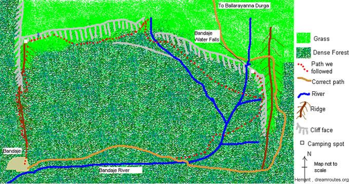
| |
Due North...
By Hemant Murthy
To start of, let me
tell you our actual plans before I go ahead and describe what exactly
happened. We were to trek from the village of Bandaje to Arrabbi
Bandaje waterfalls, and then from there trek to the fort of Ballarayanna
Durga and go ahead to Samshe via the villages of Maidaadi and Elniru.
All this was to be done in three days, starting from the 2nd of
October to the 4th of October. But destiny had other plans for us,
and that is what I describe below.
What a bus!
After a lot of last minute
additions, drop outs, planning, and booking, we finally ended up
with a group of nine people - Hemant (Hamy), Animesh (Himalaya Putra,
Shambu), Prashanth, Kiran (Pinky), Gerry (the only girl in the group),
Gaurav (Sher), Kapil, Mahesh and Suhas. Due to Animesh's heroic
efforts, we got 9 tickets to Dharmasthala through "Genral Travels".
The bus turned out to be a last-minute special bus, which was special
in the sense that it was probably taken out from the junk yard to
accommodate for the extra rush that day (long weekend, you see).
Anyway, after a rather rough ride of 7 hours, we reached the temple
town of Dharmasthala at about 7 AM.
Day 1
Reaching Bandaje.
After getting our luggage (comprising of 9 rucksacks,
8 sleeping bags, 7 sleepmats, 3 tents, lots of food, lots of water
and lots of chocolates) out of the bus at the bus stop, we asked
around for means to get to Mundaje, which was one of the starting
points for our trek. But we were told there was no direct bus to
this place, and instead, we were asked to catch a local bus to the
town of Ujjire. We did just that, being lucky to get such a bus
within 10 minutes, and on reaching Ujjire, we caught two jeeps to
transport us and our baggage to Bandaje (we decided against starting
the trek from Mundaje, since we were a little short of time). We
reached Bandaje, a small village of about 10 houses, at about 9:00.
After washing up a Gouda's place and having a quick breakfast of
chappatis, jam and chutney pudi, we started off towards the waterfalls
at about 10. Or so we thought...
Due North
According to the locals, we were one of the first groups
to attempt climbing to the falls after this monsoon. They told us
the route would not be very straightforward since the path would
be covered with growth. We passed a few houses and after asking
a local woman for directions, we started walking through the forest
and up a ridge. We realized only later that we were headed the wrong
way, Northwards!
The actual path was supposed
to head Eastwards (which we did not know), but we headed northwards.
There was no path at all, and we started hacking our way through
the forest. The ascent became steeper and steeper and it was only
after climbing for about 2 hours that we realized we were actually
headed the wrong way. At that point we did a quick check on the
map and we managed to locate where we were. We had an option of
heading back, but the slope we had climbed up was too slippery,
due to the recent rains, or was made of loose pebbles, making it
hard to get a grip on the ground. We decided to continue the climb
northwards and reach the edge of the cliff and then try a way to
head upwards from that point.
The progress was very slow, because of the dense forest
we were walking through and because of the slippery ground. At one
point of time, we realized we were headed towards the left of the
cliff, meaning that we would have reached to the base of the cliff
instead of the top. At that point we turned eastwards and after
negotiating our way around the base of the cliff, we were back on
track on the correct side of the ridge. This part was very tricky
because of the slope of around 50 degrees, which was made of loose
pebbles and rocks. After this, we again headed northwards.
 |
The climb
was getting more and more difficult. We had to reach the grasslands
at the top of the ridge as soon as possible. The forest was
much denser, and ground had become muddier. At one point we
say signs of elephant activity - Huge piles of dung and big
foot prints, and a path going upwards that was certainly created
by a pachyderm, judging from the broken trees and bushes. We
decide to follow this path. We slowly made out way to the top
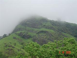
and at about 3:00 PM, the forests opened out into the open grasslands.
What we saw ahead made
our hearts sink a little. We had reached the edge of a cliff.
And from where we stood, it seemed like the cliff was not so
easily scalable. We walked a little ahead along the base of
the cliff eastwards, but progress was slow because of the slippery
rocks and the almost shoulder high grass that cut our hands
and feet. We decided to head back to the open area at the base
of the cliff and camp there for the night, since it was getting
too late. |
Camping for
Night 1.
While the others setup the tents, Kapil, Prashant, Animesh
and I took turns to fill up the water bottles at a small waterfall
nearby. We all got wet completely in the attempt from the spray
of the fall. By the time we got back, the tents had been put up.
There were two big tents and one small one. We put our entire luggage
into the small tent, while we slept in the other two. For dinner,
we made Wai Wai noodles and some chappatis (Earlier in the day,
we had had a lunch of biscuits and some chappatis and apples).
The view from our camping spot was spectacular. Once
the clouds cleared up, we could see a cliff running eastwards, to
the north and very close to the camp. We speculated a lot as to
whether we would be able to scale the same to reach the grasslands
at the top. To the west, we could see the Kudremukh range while
to the south-west, we could see the fort of Jamalabad. To the East,
we could see the waterfall and a number of other hills. Towards
the south-east, we could see the route from Mundaje to the waterfalls.
The view in the early hours of morning was also very impressive.
The clouds had settled down in the valley and looked like a lake
of white.
We were all off to sleep early, because we knew we had
a long way to go the next day. Gaurav kept the lions away with his
snores ;)
Day 2
Walk along the cliffs
We all woke up before 6 AM. No scope for brushing our
teeth, because of lack of water, so we started packing up. We made
some nice tea and had biscuits and chappatis for breakfast. At this
time, Kapil and I thought of checking out the cliff and seeing if
it was really scalable. The cliff looks illusively simple to climb,
but it is nowhere near that. It took us almost half an hour to climb,
and our hands and feet were badly cut by the shoulder high grass.
Kapil went ahead and came down with the news that scaling the cliff
face would be very very risky, if not impossible. So we abandoned
the idea and decided to walk eastwards, along the cliffs, towards
the falls. There was a gap in the cliff shown on the map and we
thought we would be able to climb to the top at that spot.
Walking along the cliffs in that forest was not at all
easy. We had to find alternate routes very often, because the forest
was too thick or because we reached another big boulder, a cliff
or sudden drop. Kiran hacked a way for us, while we kept an approximately
eastward bearing. The forest was thick and our progress was very
slow. We were covering a distance of less than a kilometer in one
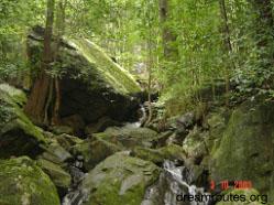
hour. On the way, we passed a couple of small waterfalls, where
we stopped for rest, biscuits and to fill up our bottles. The air
felt more and more humid and hot as we reached noon. At about noon,
we reached the break in the cliff.
Here, we found a slope through the forest that went
upwards towards the top of the cliffs. This seemed to be a difficult,
but manageable climb, and we started off on all fours. At about
1 PM, we reached the base of another cliff. We continued around
the cliff, and eventually got to the place between the two cliffs
that we had seen on the map. It was a beautiful place. The path
we took looked like a tunnel, with one of the cliff's overhang forming
a ceiling above us. But we were in for another shock. The slope
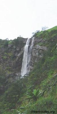
leading to the top of the cliff was broken by another waterfall.
The wide gap and fast flowing water made it impossible for us to
cross the chasm without great risk. We did not have a rope with
us, but even with a rope, this crossing was difficult.
Climbing
the ridge
After this second disappointment, we had no other
option but to backtrack and find another way to reach the waterfalls.
We now realized that we were running out of time, and we had
to find a decent camping spot. The forest was hardly an option,
because of the presence of wild animals, and also because it
was too dense to even walk through, let alone pitch a tent.
We quickly came up with
a plan of descending into the valley through the forest, crossing
the Bandaje river and trying to climb up the top of the ridge
that led to the falls (the ridge that we missed on day 1). We
then thought we could climb along the ridge to the falls in
time, or atleast find an open spot to climb (since most of that
ridge is grasslands).
|
 |
We started our difficult
descent into the valley, again cutting through the forest and slipping
and sliding on the muddy slopes, and by 2:30 PM, we reached Bandaje
river. It was a delightful sight, the river flowing fast over rocks
and boulders, most of them covered with green moss. We were totally
surrounded by forests, and at this spot we could almost see the
waterfalls. We were very close to the base of the falls. Here we
had some more grub, and then started the most difficult climb of
our three-day adventure.
We were on the west of the ridge and we had to reach
the top. We decided to go for it the hard way - a direct climb along
the side of the ridge. The slope was about 45 to 50 degrees, and
was extremely muddy and slippery. And the entire slope was covered
with the same dense forest. This time, Suhas led the way with the
knife to hack out a way for us. The climb was slow, and with ever
three steps forward, we almost slipped back one step. This was the
second time we were climbing almost the entire height of the ridge,
and we were exhausted. By 4:00 PM, we reached another obstacle -
Another cliff!
Camping near the falls
At this point we knew we were in serious trouble. We
had only about 2 and a half hours of daylight left, and we were
not sure if we would be able to make it to the top. Going down was
hardly an option, and we started making out way around the cliff.
We first headed away from the falls (southwards). After about half
an hour, we found a way around the cliff that climbed over it and
led towards the falls (Northwards). But progress on this path was
extremely slow. Kiran had taken over the lead again, and he hacked
out a path through the thick growth. This path was along the side
of a cliff face, whose slope exceeded 70 degrees, and was sometimes
only wide enough to allow a person to climb sideways. The slope
of the path itself was steep enough to force us to climb on all
fours. Every step was calculated, and we were moving at a snail
pace of about 4 or 5 steps a minute. By this time, even the weather
turned against us and it became cloudy, hampering our visibility.
We could hardly see what was beyond 10 meters of us. We knew we
had reached very close to the falls since we could hear its roar.
But we could not see it.
 |
Very soon,
we ran out of time. It was 6:30. We were no where near flat
ground. We had reached the only open place in the climb - Between
a boulder that overhung the cliff side and the cliff wall itself,
there was a slightly open area of about 2 meters by 2 meters.
It sloped a little bit, and on one side we had the cliff wall,
on another the boulder, on the third side, we had a couple of
trees and on the fourth side we had the path that led to falls.
We decided that we would all stay in this place for the night.
We were sure that we would find a way to the top the following
day, and we were also sure we would never be able to descend
the way we came up. And that was the only way up to the spot
we had reached!
We placed our bags around the spot and the nine
of us somehow managed to huddle into this small place. We had
to make sure that none of the bags fell out, since we were overlooking
the cliff side. We also had to make sure we ourselves did not
fall out, especially those sitting on the edge. It began to
rain, so we took out the outer rain cover of one of the tents
and draped it over us, tying the ends to the trees that surrounded
us. When this was not sufficient, we took out the second tent's
cover too, and draped that over the entire group. We had covered
the ground with sleep mats, and that helped a lot. While Prashanth
and I leaned against the two small trees for support, hoping
they would not give way, Animesh was sitting dangerously close
to the cliff side, while Kiran and Suhas with their backs against
the cliff wall. The rest huddle in between us. With feet and
hands entangled, it became very difficult for any of us to move
without disturbing the others position. In all this mess, we
managed to make a meal of biscuits and some pre-cooked noodles.
The rains continued to lash the area, and our feet
(especially those of the ones on the edge) were soaked, along
with our shoes, socks, bags, etc. It felt rather miserable out
there, but being with the rest of the group made each of us
feel much better and safer. We never bothered much about what
insects were around (there were many, and since we were close
to the falls, there were would have been some crabs too). None
of us really got much sleep, so we spent time singing and cracking
jokes. All this helped keeping our mind off the daunting task
of spending 11 hours in that position.
|
By 10 PM, the rains stopped
and clouds cleared out. The dim light from the half moon covered
the entire area. We could see in the valley below, far off, the
lights in the villages. But what surprised us the most was what
we saw when we looked towards the falls. We were actually sitting
about 60-70 meters from the falls. And we were near the middle of
it! We were neither at the base of the falls, not were we at the
top. We were in the middle. We could also see that there was no
way we could climb ahead, as a steep wall of rock separated the
top from where we sat. We had to head back. We had to head back
the same way we thought was impossible to descend. We also realized
that we did not have the time to make it to the falls and also make
it back to Bangalore on time. We had to abandon the plans of reaching
the falls altogether, and find our way back to the village of Bandaje.
At this point, we realized we had mobile connectivity, and that
was reassuring (we could at some time call in for help, right? :)
This had been the most exciting day of the trek. Starting
from trying to reach the waterfall on time, hacking through forests
and climbing steep and slippery slope, we had ended up in the middle
of nowhere, with the realization that we had to now find our way
back to the village. We were so close to the falls, and yet so far.
In the end, we all managed about 2-3 hours of broken sleep, and
after what seemed like an eternity, it was sunrise.
Day 3
The impossible descent
Morning welcomed us with more rains. But this
bad weather did not last for long and very soon we had sunshine.
By 8:00 AM, we were on our way down, after a breakfast of biscuits
(surprising, how survived so much on biscuits). Just before this,
Kiran tried to find some way of getting to the top, but gave up.
It was not possible to climb the wall safely. And we had a vertical
height of more than 80 meters to climb.
The descent was, as we guessed, easier said than done.
Loose rocks and muddy soil made it extremely difficult to come down
and many times we had to rely on trees for support (which many times
also gave way due to the weight, since they were all decayed). Our
plan was now to head back down into the valley and cross the river,
and then follow its course to the village. After about 2 hours,
we reached the end of the cliff and started descending into the
valley. The usual slip and slide and rock and roll continued, not
to mention crossing more insect (Especially leech) infested areas.
By 11:00 heard the roar of the river nearby and followed the sound
to reach the banks of the same. And this time, luck was on our side.
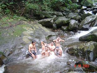
Bathing
in Bandaje Hole (River)
We had reached a spot that was excellent for bathing.
It was perfect in every way. We had the river water flowing
fast over rocks that we could sit on while the water flowed
over our bodies. We did not hesitate one bit to strip to our
undies and enjoy the pleasures of a long-required bath (we were,
by then, coated with mud). We spent a good half an hour in the
water, almost forgetting that we had to reach the village soon.
After the bath, we felt disgusted, when we realized we had to
get into the same dirty shoes and find our way back. At 12,
we left the place and headed towards the village. |
 |
Walk along the
river
We knew more or less where we were, and from the map
(which was almost destroyed by the rains and the fact that someone
set on the map case in our congested camping spot the previous night)
we knew we had to walk as close as possible, along the river in
a southwesterly direction. This was not easy, considering we had
entered, what was probably the most dense part of the forest. Many
a times, we realized we were walking away from the sound of the
river and turned left to reach the river again. Keeping the course
along the river was not easy, since our path was obstructed by thick
growth, boulders and trees. We had a brief stop for lunch of Pongal
and Bisibele bhat when we reached the river for the third time.
Throughout the walk in the forest, we saw signs of wild life - Elephant
tracks, pug marks of some big cat (rather fresh), a couple of diamond
back vipers, crabs, scorpions, etc. By 3:00 PM, we were all worried
that we may end up spending another night, this time in the forest.
And that's when our luck changed for good.
The path to Bandaje
We reached a clearing in the forest. And there we saw
a pit. This was no natural pit, it was man-made, judging from the
stones place around it. It meant we were somewhere close to civilization.
We continued ahead and saw a tree with a small board shaped like
an arrow pointing towards the river. There was nothing written on
it, but when we looked around the area, we realized we were standing
on a path. It was very distinct. One end led towards the river,
while the other end led to a southwest direction. We had found the
path which we were supposed to take on day 1! This was a very big
relief for everyone, as we quickly gained speed and walked a brisk
pace towards the village.
By 5:00 PM we had reached the first house of the village.
We were back into safe territory! We asked the locals how we could
get back to Dharmasthala and they told us to go to the house of
one Narayana, who lived about half a kilometer away. We reached
his place and he told us the jeep would be there by 8:00 PM. He
was kind enough to offer us his place for rest. We all had a bath
in his house (outdoors, with water being pumped through a big pipe
through an irrigational pump). His wife made us some great tea.
We even got to pet a 5-day old calf in his place. It felt great
to have a bath and get into clean clothes, sipping hot tea while
enjoying the cool surrounding of the village. The jeep arrived at
his doorstep by 7:30 PM, and we loaded our luggage and ourselves
into the jeep. After spending a night in that wet and cramped camping
spot the previous night, this seemed like luxury as 6 of us and
the luggage sat behind, while 3 of us sat ahead with the driver.
Adventures never end.
The village roads were narrow and allow only one vehicle to pass
at a time. If two vehicles come in opposite directions, they both
have to go a little off the road onto the dirt on the sides. This
happened at one time when another jeep came from the opposite direction.
What our driver did not notice is that there was a deep pit on the
side and he took the vehicle right over it. It came to a grinding
halt with the left rear wheel dangling over the 2-3 meter high pit.
Any further and we could have toppled over! The people from the
left side first got off, then the remaining passengers. We managed
to tilt the jeep more to the right while the driver got into gear
and drove it out to solid ground. Like 3 days of the adventure that
we already had wasn't enough, that we also needed this to happen!
We never stopped wondering what would happen next.
Back to Bangalore.
After that exciting jeep ride, we reached Dharmasthala
at about 8:30 PM. Kiran managed to book us into an ultra deluxe
bus which would leave at 10:00 PM. We had dinner in the Kamat hotel
at the bus stop, our first proper meal since the start of the trek.
We had meals, along with Mangalore buns and bhajjis. Mmmmmmm. By
10:00, we and our stinky baggage were in the bus (much to the agony
of our fellow passengers). By 7:00 AM, we were back in Bangalore.
What a delight it was to be back. The nine of us had
been through some adventure. I think we would now be able to take
on any sort of trek in the future after what all happened on this.
I think we will also appreciate the luxuries that we have a lot
more than before. But what really got us through was the team sticking
together. None of us lost our tempers and none of us expressed any
negative thoughts. Special credit goes to Gerry, the only girl in
the group, who had come all the way from Hyderabad for this trek,
for constantly smiling through all our problems. All of us encouraged
each other and in the end we came out alive. And luck does favour
the brave...
Love,
Hamy the Veggy ;)
6th Oct, 2003
PS: I've not named the report the usual way (Trek to ..., etc) since
we never reached where we intended to :). I've named it "Due North"
since we started off day 1 always heading due north.
|
|